UNCONSOLIDATED QUATERNARY
DEPOSITS
Widespread
deposits of silt, sand, and gravel are not common on valley floors of the
Mitchell area, even adjacent to the John Day River. This is because uplift has
been underway and erosion dominates aggredation while
most streams flow on or close to bedrock. Summer thunderstorms sometimes cause
alluvial fans and sheets
of mud to be deposited locally, but they are soon removed by subsequent floods.

During Pleistocene time, conditions were very different. Although
glaciers were not present in the Mitchell area, rainfall was much more abundant
than it is now and valleys were characterized by broad alluvial plains covered
with gravels.
These deposits now survive on isolated terraces and broad pediments where eroded hard-rock detritus (such as PGB) rests upon
(and protects) soft rocks such as tuffs and mudstones.

Subsequent erosion of these pediments has produced many isolated hills and ridges of soft bedrocks capped by basaltic gravels.

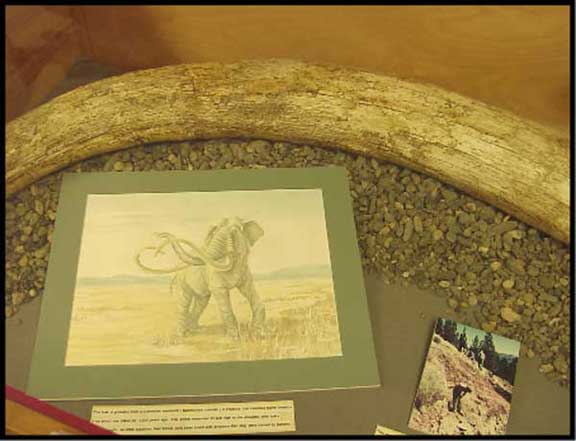
It is within adjacent stream deposits that tusks and molars of Pleistocene mammoths have been found in the Mitchell
area.
Tuffs of John Day
and Clarno Formations contain abundant smectite clays and when they become wet, provide a
“lubricant” for extensive landslides.

In this way, large Pleistocene landsides were produced, especially
where tracts of rock fragments rested upon the mobile clays.

The valley of Gage Creek and the lower one-half of Meyers Canyon
received these landslides in such volume that stream erosion could not remove
the accumulation of debris. In both of these valleys, seasonal storms have
maintained a deep trench in the alluvial fill and exposed a bed of 7700-year-old
Mazama ash in the upper one-half of the deposits.


The Mazama ash from the culminating
eruptions of Crater Lake is easy to recognize because the ash is composed of
fresh glass shards, crystals of black hornblende, and is gritty to the touch.
I have watched several floods from summer thunderstorms completely fill and re-excavate the Meyers Canyon trench within a single day.
Smaller-scale landslides occur locally, such as on the east slope
of Sargent Butte where dissection reveals the landslide deposits in cross
section.


On gentle slopes at high elevations, repeated freezing and thawing
of the soil has produced a patterned ground where stone stripes are common.

Streams of the
Mitchell area have been superimposed from a much higher topographic level where
rivers coursed over broad alluvial plains. Entrenched meanders occur in the course
of the John Day River and many tributary streams, such as West Branch, Bridge
Creek, and Meyers Creek.
They now bisect resistant intrusive bodies instead of following a
course on adjacent soft rocks. Consequently, many hillsides
are characterized by steep cliffs and aprons of talus.

Recent volcanic
activity in the Mitchell area has occurred only once and is represented by a
cinder cone on a small basaltic shield volcano west of the locality of Antone.
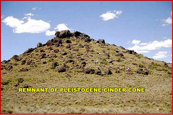
The cinders have been mostly removed for constructional purposes.